How I Get Leh'd.........Again - Manali to Leh Cycling June 2018
Manali-Leh Highway Synopsis
Long
ago it was the ancient trade route and an important connect between India and
China for many centuries. Then sometime around the mid 1980’s the bikers
started exploring the route and bringing back stories of a ‘far away land’
whose beauty was in its emptiness and whose charm was the challenge it throws
at the travelers in the form of rough terrain, rugged roads and high altitude
passes. In the next two decades, the world was flooded with pictures of the
barren-landscapes initially in form of post cards & then via social media and
the Manali-Leh highway started finding a place almost in every adventure
seekers bucket list.
Manali-Leh
Highway is one of those Highways which offers almost everything to an adventure
lover that is available with nature. More than 300 kilometers out of 480 kilometers
long Manali-Leh Highway, does not have any civilization. You would be the only
soul wandering on most part of your journey. Even one cannot find fuel (petrol
or diesel) for 365 kilometers on Manali-Leh Highway.

The type of transport
one uses on this route actually grades the travelers into various categories of
adventure seekers. Listed below are the four grades of travelers, that I found during my epic journey.
1) The most common ones
are on four wheels – Self-drive to taxis
to the tempo travelers.
2) Then comes a little
higher grade of adventure seekers – the motor bikers. For bikers, riding motor-bikes there in Himalayas is, perhaps, the ultimate
adrenaline rush one could get.
3) A little higher grade (Crazy) of adventure seekers belongs to cyclists who peddle up 480 kilometers of the spectacular
landscape in a span of 9-10 days to enjoy a feeling that no other
motorized ride can ever give.
4) At the top of the pyramid, there are some human-beings (Don't know if they are human actually), who "run" the epic route in flat 5 days. (Yes, you read it right - running it is).

When & How I got Leh’d - Again
Oh yes, Leh'd I was.
For
once in our life, perhaps, each one of us would want to have a road trip to the
second largest district of India. This is one legendary trip that every Indian
die for, especially the adventure lovers. And if you are lucky, you may get a
second chance to do it one more time. And if you are Ritesh (one of the participants
in our cycling batch), you might be doing 3rd road trip to
Leh-Ladakh. I’m just back after getting Leh’d – again (for the second time).
After doing a road trip to heaven on the earth (Leh) from National Highway
Numbered 1D via Srinagar in 2009, I got a chance to visit the place again in June
2018, this time from NH3 via Manali. It would really be difficult to tell if
NH1D is better than NH3 or vice-versa. The beauty of snow-capped mountains, the
green meadows, rugged roads, beautiful weather makes this journey a memorable
one, wither you choose NH1D or NH3. There will also be rocky passes, hard
weather conditions, storms and acute mountain sickness (altitude sickness)
conditions, but the scenic beauty on the trail makes it worth a while. After
all, a trip to Leh is not just about the destination but it is the whole
journey that makes it memorable.
Manali to Leh highway (NH3), a 480km
long journey, is a pilgrimage for two wheel riders – either bikers or cyclists.
On one side it is one of the world’s most extreme roads trips and on the other
side, it is also one of the most spectacular and scenic drives in the world. I
was introduced to this route a few years ago when I watched a YouTube video
about this highway. And a few Bollywood movies added fuel to the fire. Since
then, it had been my dream. Come, December 2017, and I began planning for this
ride in June 2018, and it turned out to be the ride of my life.
11 clowns from different parts of India and from
different backgrounds decided to shake hands for this epic bicycle journey
which takes you from the green valleys of Manali to the mountain desert of
Leh-Ladakh.

All
of us started our journey on 15th June to reach Manali by 16th June,
which serves as a start point for the epic journey to Leh.

Manali, situated in the heart of snowy mountains at a height of >6,700 feet above sea level, is a gorgeous hill station located in the state of Himachal Pradesh. It is situated in the Kullu valley, because of which it is very often known as Kullu Manali. We all met in the decided hotel in Manali and had a brief introduction rounds with each other. Each one of us had different plans for a date with Manali on 16th June; some went for rafting, some went for paragliding, some went for cycling before cycling trip, some went outside exploring local markets and a few lazy ones like me decided to stay in the property. A few of us played a couple of board games in the hotel (Spot It and Coup being the winners for the day). After having early dinner (my first dinner before 8.30pm in the long-long time), all of us headed towards our rooms to enjoy the last sleep on the ‘bed’. (We were going to get our sleeping beds only after we had reached Leh and were supposed to enjoy the nights in sleeping bags for next 7 days).
 1) Manali to Marhi Via Kothi – 38km
The epic journey on NH3 started on 17th June with all of us leaving for Marhi. Majority of the roads were smooth and in best possible condition till Marhi (except for last 2-3 kilometers), however traffic was also at its peak through-out the day. We being on cycles, did not face any challenge due to traffic and kept on moving regularly. This is the advantage which no other vehicle (except cycle) gets and there is no better feeling than beating the 4-5 kilometer long traffic.
 It
was pouring continuously and we soon realised the mild windproof cover wouldn’t
suffice, so we all put on our proper rainproof jackets and started the fairly
steep uphill ride, on excellent tarmac. Pouring/drizzling accompanied us for
most of the day and thankfully it never got converted into heavy rain.
It
was pouring continuously and we soon realised the mild windproof cover wouldn’t
suffice, so we all put on our proper rainproof jackets and started the fairly
steep uphill ride, on excellent tarmac. Pouring/drizzling accompanied us for
most of the day and thankfully it never got converted into heavy rain.
 One has to cross the Gulaba Check Post on the
way to Marhi/Rohtang-La pass and show the permission pass, which needs to be
collected at Manali. However, cyclists are exempted for taking any such
permission.
One has to cross the Gulaba Check Post on the
way to Marhi/Rohtang-La pass and show the permission pass, which needs to be
collected at Manali. However, cyclists are exempted for taking any such
permission.


The first ascent of the trip prepares up for the tough ride ahead and takes you through the panoramic view of pine and deodar trees. One has to negotiate many hairpin bends to reach Marhi. The view from top of a hill, just before Marhi Market is so beautiful that one can spend hours over there talking to nature in pursuit of finding himself.
 Marhi
is a small town of roadside restaurants (dhabas), located at a distance of 35km
from Manali and is situated at 3350 meters (~11k feet) above sea level
altitude. The place is fully covered with snow in winter. Whenever the
authorities close the Rohtang Pass for the winter season, they allow visitors
to come up at Marhi to enjoy the lush green meadows and scenic beauty. Post-paid
connections work in some parts of the Marhi while prepaid mobile connections
don't get signals once you reach Marhi region.
Marhi
is a small town of roadside restaurants (dhabas), located at a distance of 35km
from Manali and is situated at 3350 meters (~11k feet) above sea level
altitude. The place is fully covered with snow in winter. Whenever the
authorities close the Rohtang Pass for the winter season, they allow visitors
to come up at Marhi to enjoy the lush green meadows and scenic beauty. Post-paid
connections work in some parts of the Marhi while prepaid mobile connections
don't get signals once you reach Marhi region.
2) Marhi to Sissu Via Rohtang La and Koksar – 50km
From Marhi, one has to climb about 16-17 kilometres to reach Rohtang La Pass (13057 feet above sea level), also known as valley of death. The road condition is excellent till Rohtang but nature mother presented some challenges in the likes of heavy rains, headwinds and steep climb. The fingers were numb by the time we reached at the top and some of us tried to negotiate with freezing cold via putting hands on red hot Bike silencers. We barely spent 5 minutes at the top and decided to march towards Sissu as it was getting darker because of clouds and continuous rains.
Roads downhill from Rohtang (for about 10-12 kilometre long stretch) were mostly bad. The excellent tarmac suddenly disappeared and the roads started becoming a nightmare. Rains had turned it slushy and tricky. By the time we reached Koksar (the first village on the road down), our clothes got painted with dots of mud, some as small as water drop and some as big as one rupee coin


Situated
at 10245 feet above sea level, Koksar is one of the villages in Lahaul. About
19 km from Rohtang Pass, Koskar is the coldest place in Lahaul. It is mostly
snowed in during winters but during the summer months, the place is back in
business. Agriculture is the main source of livelihood and Potato and Peas
farming is very common in the village.

From Koksar, one can go either to Leh or Kaza (Spiti Valley) depending on the journey one wants to cover. The road conditions improve dramatically once you cross Koksar Bridge and the excellent road to Sissu is more or less a plain (just like outer ring road of Delhi with a handful flyovers).
On the way to Sissu, one can notice the heavy construction work going alongside the river, making it an opening for Rohtang Tunnel. This 8.8 km long tunnel, once ready, will reduce the distance between Manali and Sissu by ~50 Kilometre, and will provide all year and all weather access to people/ As of now, this road remains closed for more than half of the year as the Rohtang pass is blocked by snow.
Mobile phones hardly get any signals there in Sissu, be it the post-paid connection or prepaid one. The campsite in Sissu was among the best sites of the trip, it being surrounded by sky touching mountains, Chandra River just besides the camp, a long waterfall on the other side of the river, a small lake for people who love boating and a helipad hardly at a 200 meters distance.
Situated at 3120 meters or 10235 feet above sea level, Sissu is a small town in the Lahaul valley of HP with Hindi as its local language. Sissu, in the foothills of the Pir Panjal mountains range, is approximately 90 kilometre from Manali and located on the right bank of Chandra River. It is famous for beautiful campsites for travellers travelling on Manali-Leh highway. It has a heart shaped waterfall, a small lake for boating, and an army helipad.
3) Sissu to Jispa Via Tandi and Keylong – 55km
Chandra river accompanies from Sissu till one reaches at Tandi, a place where it meets Bhaga river to form Chenab (Chandra-Bhaga). Tandi has an army transit camp and an Indian Oil Petrol pump which reads a signboard – ‘Next Filling Station 365 kilometers ahead. This petrol pump serves as ‘mecca’ for any passing by motor vehicle. Crossing a small Tandi Bridge, one moves to the other side of the river and starts his journey for Jispa, mostly upwards except for 6 kilometer downhill at the end of the day’s journey

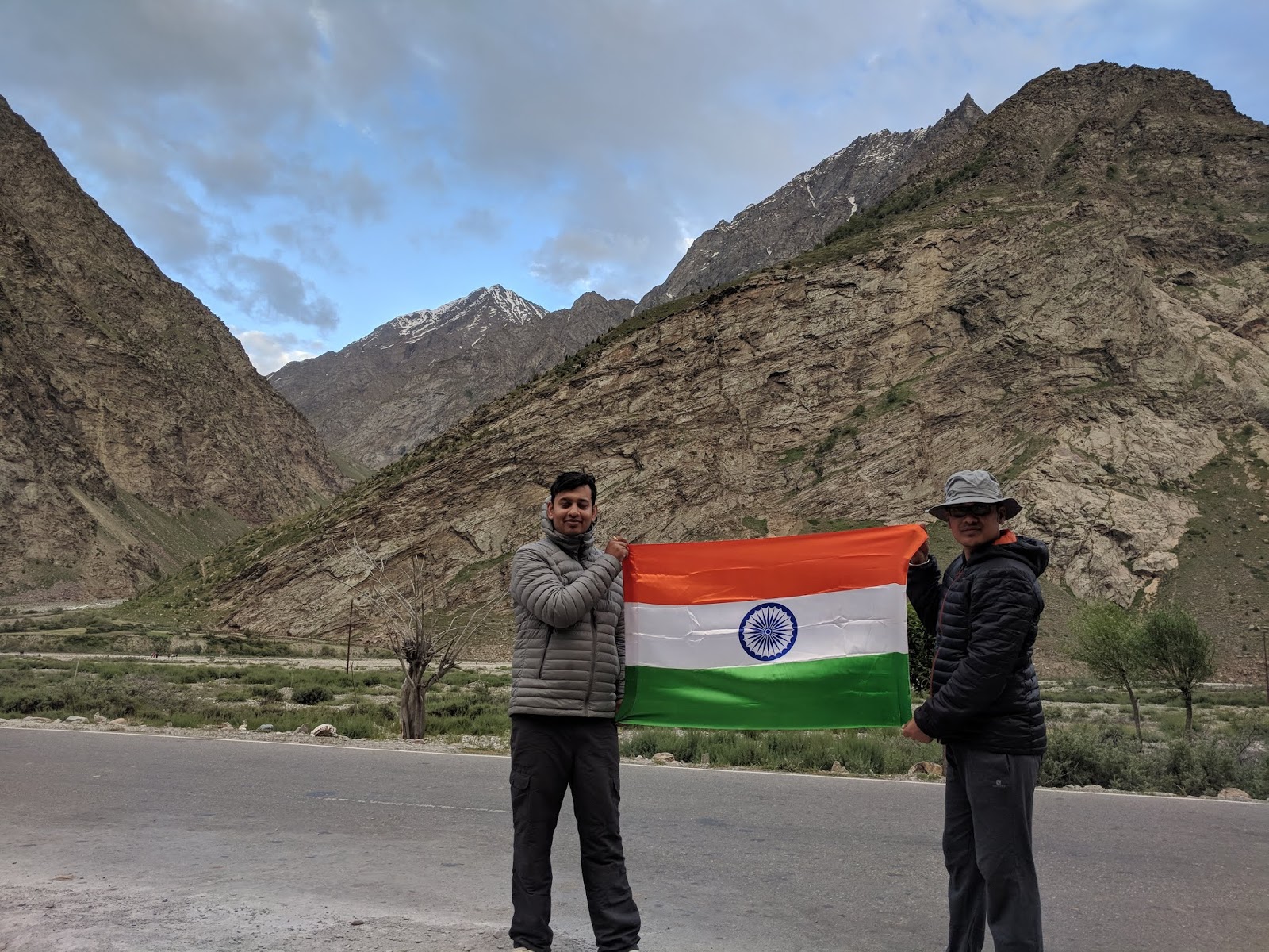
The location of campsite at Jispa, make you feel like you are in Kargil area where our brave soldiers fought the 1999 war against arch rivals Pakistan. We could not resist ourselves and we decided to wave national flag and get a few pic clicked with the tri-color.
4) Jispa to Zing-Zing Bar via Darcha and Deepak Tal – 37km
The journey starts with steady climb to Darcha, approximately 10 kilometer from Jispa and another 10-12 kilometres journey takes you to Patseo. The terrain is mix of concrete road, dusty patches and some small streams flowing over the road. Today is the day when one can feel the gradual change in landscape with green valleys started disappearing and dry mountains started raising their heads. On our way we we found beautiful Deepak Tal Just before Patseo. After having tea and a few clicks at Deepak Tal, we were on our way to Zing Zing Bar (ZZ Bar). After a total of 30 kilometre ride from Jispa, you finally see a signboard stating – ZZ Bar, 0 kilometer. ZZ Bar looks like a collection of 3-4 Dhabas where one can enjoy the hot Maggie and tea. ZZ Bar serves as a windy campsite and the sky touching Barlacha-La pass is just 16 kilometre away from here. Wind was very strong in the evening in ZZ Bar, which made us worry about our tents, however they survived.
5) ZingZing Bar to Sarchu Via Baralacha-La – 50km
The day started early and we ascended the mountains up to the Baralacha-La pass at 16175 feet above sea level. On the way, one crosses Suraj Tal (Sun-Lake) situated at 15500 feet above sea level, with the snow-capped Mountains forming a scenic backdrop. The pass is infertile with no vegetation. Roads downward were mostly good with few bad stretches. We reached Bharatpur by the noon and had our lunch their at Bharti Dhaba. During discussions Bharti, the owner of the dhaba, told how she and her family have to move place to place to earn their livings. (She spends 4 months, June-September in Bharatpur when Manali-Leh highway if open, 4 months, Feb-May in Manali and remaining 4 months, October-January in Delhi NCR). It was the same routine for all 4 dhaba owners there in Bharatpur. We soon started our journey towards Sarchu and reached Killing Sarai where descend ends, and almost flat roads with tailwind takes you to Sarchu from Killing Sarai.
6) Sarchu to WhiskyNala Via Gata Loops and Nakee-La – 47km
The day starts with some relatively easy cycling, mainly plains, but soon you will find yourself negotiating ‘21 loops of Gata’ that zigzag all the way to the summit of Nakee-La at 16565 feet altitude. A short downhill section and you reach WhiskyNala.

 Gata loops, or the 21 hairpin bends, take you from 13780 feet above sea level to 15190 feet of height in distance of 8 kilometers. To say that these
hairpins are relentless would be an understatement. They are a killer and with each passing
pedal, the body seemed to say, Why are you doing this to yourself? And
just when you finish the loops, you realize there is more in store, a lot more,
in fact. The climb does not end there as one has to go upto 16565 feet altitude to reach Nakee-La pass.
Gata loops, or the 21 hairpin bends, take you from 13780 feet above sea level to 15190 feet of height in distance of 8 kilometers. To say that these
hairpins are relentless would be an understatement. They are a killer and with each passing
pedal, the body seemed to say, Why are you doing this to yourself? And
just when you finish the loops, you realize there is more in store, a lot more,
in fact. The climb does not end there as one has to go upto 16565 feet altitude to reach Nakee-La pass.
7) Whisky Nala to Debring via Lachung-La & Morey Plains – 84km
A 7 kilometer steep ascent takes you to Lachung-La at 16616 feet above sea level and a long rugged road descent takes you to Pang at 15230 feet above sea level. Mountains on the way to Pang were made of sand and rocks and those shapes created by rains and wind will amuse you. The road from Lachung-La is like hair-raising downhill that will test one's riding abilities and breaks of the bikes. Pang plays as host to the highest army transit camp, anywhere in the world.
From Pang, an 8 kilometer switchback climb will lead you to the flat top of the Morey Plains at 15419 feet altitude. Morey plains is a long stretch of flat area, which is quite unusual at this altitude. This barren area is known for its extreme temperatures in the morning and evening, fast winds and sandstorms.

8) Debring to Lato via Tanglang-La – 50km
The day starts with challenging climb that leads to the one of the highest motorable passes in the world - Tanglang-La (17580 feet above sea level). An exciting descent from Tanglang-La takes you to the village of Lato and one can see the beautiful green patches of small Ladakhi farms, the Gompas, and barren mountains in the backdrop.
9) Lato to Leh via Upshi – 70km
It’s one of the easy days though the distance is approximately 70 kilometer; the roads are almost flat, weather is comfortable, altitudes are comparatively lower. Thicksey Monastery and Rancho School are the key attractions on the way. This is the day you get back to civilization and all home comforts.

--
Overall, the experiences we all gained during 10 days of the epic journey are immemorial. The entire duration of the journey is like a test of stamina, endurance and mental strength. We faced lonely long roads, raging winds, high altitude sky touching passes, weather that can chill you to bones, rain, a mini snowfall and the scorching sun. But what made all this bearable and absolutely worth it were the changing landscape of towering mountains. Every mountain makes you feel that you are just a little creation in the scheme of things of world. This epic journey and the rugged roads who led me to fulfill my dream taught some important lessons of life.
1) No matter what ever the conditions are, the roads continue their journey and do not stop for anyone.
2) If we experience the life by stepping out of our comfort zones, only then we realise a) the luxuries that we have in metro town and b) the wonderful life we are leading.
3) You will see the sights that you often see only in postcards otherwise and by the time you will be back form this epic journey, you will have hundreds of wallpapers for your mobile and laptop screens.
Manali, situated in the heart of snowy mountains at a height of >6,700 feet above sea level, is a gorgeous hill station located in the state of Himachal Pradesh. It is situated in the Kullu valley, because of which it is very often known as Kullu Manali. We all met in the decided hotel in Manali and had a brief introduction rounds with each other. Each one of us had different plans for a date with Manali on 16th June; some went for rafting, some went for paragliding, some went for cycling before cycling trip, some went outside exploring local markets and a few lazy ones like me decided to stay in the property. A few of us played a couple of board games in the hotel (Spot It and Coup being the winners for the day). After having early dinner (my first dinner before 8.30pm in the long-long time), all of us headed towards our rooms to enjoy the last sleep on the ‘bed’. (We were going to get our sleeping beds only after we had reached Leh and were supposed to enjoy the nights in sleeping bags for next 7 days).
The epic journey on NH3 started on 17th June with all of us leaving for Marhi. Majority of the roads were smooth and in best possible condition till Marhi (except for last 2-3 kilometers), however traffic was also at its peak through-out the day. We being on cycles, did not face any challenge due to traffic and kept on moving regularly. This is the advantage which no other vehicle (except cycle) gets and there is no better feeling than beating the 4-5 kilometer long traffic.
The first ascent of the trip prepares up for the tough ride ahead and takes you through the panoramic view of pine and deodar trees. One has to negotiate many hairpin bends to reach Marhi. The view from top of a hill, just before Marhi Market is so beautiful that one can spend hours over there talking to nature in pursuit of finding himself.
2) Marhi to Sissu Via Rohtang La and Koksar – 50km
From Marhi, one has to climb about 16-17 kilometres to reach Rohtang La Pass (13057 feet above sea level), also known as valley of death. The road condition is excellent till Rohtang but nature mother presented some challenges in the likes of heavy rains, headwinds and steep climb. The fingers were numb by the time we reached at the top and some of us tried to negotiate with freezing cold via putting hands on red hot Bike silencers. We barely spent 5 minutes at the top and decided to march towards Sissu as it was getting darker because of clouds and continuous rains.
Roads downhill from Rohtang (for about 10-12 kilometre long stretch) were mostly bad. The excellent tarmac suddenly disappeared and the roads started becoming a nightmare. Rains had turned it slushy and tricky. By the time we reached Koksar (the first village on the road down), our clothes got painted with dots of mud, some as small as water drop and some as big as one rupee coin
From Koksar, one can go either to Leh or Kaza (Spiti Valley) depending on the journey one wants to cover. The road conditions improve dramatically once you cross Koksar Bridge and the excellent road to Sissu is more or less a plain (just like outer ring road of Delhi with a handful flyovers).
On the way to Sissu, one can notice the heavy construction work going alongside the river, making it an opening for Rohtang Tunnel. This 8.8 km long tunnel, once ready, will reduce the distance between Manali and Sissu by ~50 Kilometre, and will provide all year and all weather access to people/ As of now, this road remains closed for more than half of the year as the Rohtang pass is blocked by snow.
Mobile phones hardly get any signals there in Sissu, be it the post-paid connection or prepaid one. The campsite in Sissu was among the best sites of the trip, it being surrounded by sky touching mountains, Chandra River just besides the camp, a long waterfall on the other side of the river, a small lake for people who love boating and a helipad hardly at a 200 meters distance.
Situated at 3120 meters or 10235 feet above sea level, Sissu is a small town in the Lahaul valley of HP with Hindi as its local language. Sissu, in the foothills of the Pir Panjal mountains range, is approximately 90 kilometre from Manali and located on the right bank of Chandra River. It is famous for beautiful campsites for travellers travelling on Manali-Leh highway. It has a heart shaped waterfall, a small lake for boating, and an army helipad.
3) Sissu to Jispa Via Tandi and Keylong – 55km
Chandra river accompanies from Sissu till one reaches at Tandi, a place where it meets Bhaga river to form Chenab (Chandra-Bhaga). Tandi has an army transit camp and an Indian Oil Petrol pump which reads a signboard – ‘Next Filling Station 365 kilometers ahead. This petrol pump serves as ‘mecca’ for any passing by motor vehicle. Crossing a small Tandi Bridge, one moves to the other side of the river and starts his journey for Jispa, mostly upwards except for 6 kilometer downhill at the end of the day’s journey
The location of campsite at Jispa, make you feel like you are in Kargil area where our brave soldiers fought the 1999 war against arch rivals Pakistan. We could not resist ourselves and we decided to wave national flag and get a few pic clicked with the tri-color.
4) Jispa to Zing-Zing Bar via Darcha and Deepak Tal – 37km
The journey starts with steady climb to Darcha, approximately 10 kilometer from Jispa and another 10-12 kilometres journey takes you to Patseo. The terrain is mix of concrete road, dusty patches and some small streams flowing over the road. Today is the day when one can feel the gradual change in landscape with green valleys started disappearing and dry mountains started raising their heads. On our way we we found beautiful Deepak Tal Just before Patseo. After having tea and a few clicks at Deepak Tal, we were on our way to Zing Zing Bar (ZZ Bar). After a total of 30 kilometre ride from Jispa, you finally see a signboard stating – ZZ Bar, 0 kilometer. ZZ Bar looks like a collection of 3-4 Dhabas where one can enjoy the hot Maggie and tea. ZZ Bar serves as a windy campsite and the sky touching Barlacha-La pass is just 16 kilometre away from here. Wind was very strong in the evening in ZZ Bar, which made us worry about our tents, however they survived.
5) ZingZing Bar to Sarchu Via Baralacha-La – 50km
The day started early and we ascended the mountains up to the Baralacha-La pass at 16175 feet above sea level. On the way, one crosses Suraj Tal (Sun-Lake) situated at 15500 feet above sea level, with the snow-capped Mountains forming a scenic backdrop. The pass is infertile with no vegetation. Roads downward were mostly good with few bad stretches. We reached Bharatpur by the noon and had our lunch their at Bharti Dhaba. During discussions Bharti, the owner of the dhaba, told how she and her family have to move place to place to earn their livings. (She spends 4 months, June-September in Bharatpur when Manali-Leh highway if open, 4 months, Feb-May in Manali and remaining 4 months, October-January in Delhi NCR). It was the same routine for all 4 dhaba owners there in Bharatpur. We soon started our journey towards Sarchu and reached Killing Sarai where descend ends, and almost flat roads with tailwind takes you to Sarchu from Killing Sarai.
6) Sarchu to WhiskyNala Via Gata Loops and Nakee-La – 47km
The day starts with some relatively easy cycling, mainly plains, but soon you will find yourself negotiating ‘21 loops of Gata’ that zigzag all the way to the summit of Nakee-La at 16565 feet altitude. A short downhill section and you reach WhiskyNala.
7) Whisky Nala to Debring via Lachung-La & Morey Plains – 84km
A 7 kilometer steep ascent takes you to Lachung-La at 16616 feet above sea level and a long rugged road descent takes you to Pang at 15230 feet above sea level. Mountains on the way to Pang were made of sand and rocks and those shapes created by rains and wind will amuse you. The road from Lachung-La is like hair-raising downhill that will test one's riding abilities and breaks of the bikes. Pang plays as host to the highest army transit camp, anywhere in the world.
From Pang, an 8 kilometer switchback climb will lead you to the flat top of the Morey Plains at 15419 feet altitude. Morey plains is a long stretch of flat area, which is quite unusual at this altitude. This barren area is known for its extreme temperatures in the morning and evening, fast winds and sandstorms.
8) Debring to Lato via Tanglang-La – 50km
The day starts with challenging climb that leads to the one of the highest motorable passes in the world - Tanglang-La (17580 feet above sea level). An exciting descent from Tanglang-La takes you to the village of Lato and one can see the beautiful green patches of small Ladakhi farms, the Gompas, and barren mountains in the backdrop.
9) Lato to Leh via Upshi – 70km
It’s one of the easy days though the distance is approximately 70 kilometer; the roads are almost flat, weather is comfortable, altitudes are comparatively lower. Thicksey Monastery and Rancho School are the key attractions on the way. This is the day you get back to civilization and all home comforts.
--
Overall, the experiences we all gained during 10 days of the epic journey are immemorial. The entire duration of the journey is like a test of stamina, endurance and mental strength. We faced lonely long roads, raging winds, high altitude sky touching passes, weather that can chill you to bones, rain, a mini snowfall and the scorching sun. But what made all this bearable and absolutely worth it were the changing landscape of towering mountains. Every mountain makes you feel that you are just a little creation in the scheme of things of world. This epic journey and the rugged roads who led me to fulfill my dream taught some important lessons of life.
1) No matter what ever the conditions are, the roads continue their journey and do not stop for anyone.
2) If we experience the life by stepping out of our comfort zones, only then we realise a) the luxuries that we have in metro town and b) the wonderful life we are leading.
3) You will see the sights that you often see only in postcards otherwise and by the time you will be back form this epic journey, you will have hundreds of wallpapers for your mobile and laptop screens.


Comments
Post a Comment